-16%
Garmin

Montana® 700

Original price was: 649,99€.Current price is: 549,00€. VAT included

Availability: Only 1 left in stock SKU: 429901
Original price was: 649,99€.Current price is: 549,00€. VAT included

PRICE ONLY VALID ONLINE!

The in-store price may vary.

FREE SHIPPING

from 70 €
delivery within 48 hours

ONLINE SUPPORT

Mon-Fri 09.30-12.30 / 15.30-19.30
call us at +39 0438 430796

FREE RETURNS

on 100% of the product cost
you have 14 days to reconsider

Description

Robust touchscreen GPS navigator

EXPLORE THE WORLD WITH A RELIABLE DEVICE

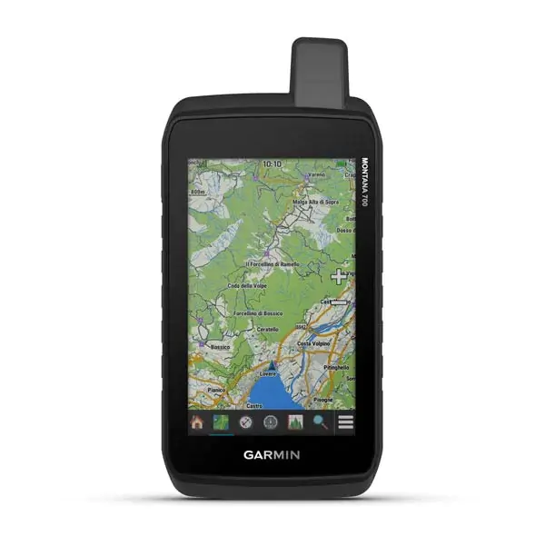
With preloaded road maps and trails, the Montana 700 handheld device offers advanced outdoor features in a rugged 5″ device, ideal for hiking, biking, motorcycling, ATVing and more.

The best of navigation at your fingertips thanks to a large touchscreen.

Preloaded TopoActive Europe maps. Now you are free to choose road or off-road routes.

Conforms to MIL-STD 810 standard to withstand extreme temperatures, shock, water and vibration.

BirdsEye satellite images downloadable directly to your device.

Explore without fear thanks to ABC sensors and the multi-GNSS network.

Experience your adventures thanks to the lithium-ion battery with a battery life of more than 18 in GPS mode.

ROBUST DESIGN

This durable and waterproof device has been tested to military standards and features a 5-inch touchscreen, suitable for use with gloves, that is 50 per cent larger than previous Montana models.

TOPOACTIVE EUROPE MAPS

For your adventures, use the pre-loaded TopoActive Europe maps. View elevations, coastlines, rivers, and more.

BIRDSEYE IMAGES

Downloading BirdsEye satellite images directly to your device (no annual subscription required) allows you to view photorealistic views and create waypoints based on landmarks.

ABC SENSORS

Take your next trail with ABC sensors; it includes an altimeter for altitude data, a barometer to monitor the weather and a 3-axis electronic compass.

WEATHER CONDITIONS

The mobile phone connection provides access to up-to-date weather forecasts via the Garmin Connect™ app.

DOG TRACKING

For hunters and trainers, Montana allows synchronisation with hand-held devices from the Astro® or Alpha® series (sold separately) to track and trace dogs.

MULTI-GNSS RECEPTION

Access to GPS, GLONASS and GALILEO satellite networks enables Montana® 700 to acquire position in more remote areas than using GPS alone.

LOCATION SHARING

The LiveTrack function allows you to wirelessly connect your device with other compatible Garmin GPS devices, so you can track roads, routes, waypoints and any adventure.

EXPEDITION MODE

Use Expedition mode to extend Montana’s battery life for a week or more. In this mode, the screen turns off, the device goes into power saving mode, but continues to collect GPS track points, albeit in small numbers.

BATTERY OPTIONS

The internal rechargeable lithium-ion battery offers more than 18 hours of battery life in GPS mode. The device can also be powered by AA batteries.

COMPATIBLE BRACKETS

A wide range of brackets compatible with the Montana handheld device (sold separately) allow the navigator to be adapted for use on motorbikes, ATVs, boats, cars, campers or other vehicles.

General

Dimensions 8.76 x 18.30 x 3.27 cm
Touchscreen
Screen size, WxH 6.48 x 10.80 cm; 5″ diagonal (12.70 cm)
Screen resolution, WxH 480 x 800 pixels
Screen type WVGA transflective dual orientation
Weight 397 g incl. lithium-ion
battery

Rechargeable lithium-ion battery (included) or 3 AA batteries (not included); lithium-ion battery recommended

Battery life GPS mode: up to 18 hours Expedition mode up to 330 hoursWaterproof ratingIPX7 MIL-STD-810 yes (thermal, shock, water, vibe) High-sensitivity GPS receiver ✓ Interface Compatible with NMEA 0183 and high-speed micro USB Memory/history 16 GB (space varies depending on maps included)

routes

Maps and memory

Preloaded cartography Yes (TopoActive Europe)
Additional cartography
Basemap worldwide
Automatic route calculation (with precise turn-by-turn directions) Yes (with optional mapping for detailed roads)
Segments map 15000
BirdsEye Yes (directly on device)
Includes detailed hydrographic information (coastlines river/lake banks, marshes, and perennial and seasonal waterways)
Includes searchable points of interest (parks, campgrounds, scenic spots, and picnic areas)
Displays national, state, and local parks forests and nature reserves
Storage capacity and power supply Yes (32 GB microSD™ card max)
Storable locations 10000
Tracks
250
Track log 20000 points 250 saved gpx tracks, 300 saved fitness activities
Storable 250, 250 points per route automatic route calculation 50 points
Recording Rinex
GPS

sensors

GLONASS
Galileo
Altimeter barometric
Compass Yes (with tilt compensation, 3 axes)
GPS compass (on the move)

Daily Smart Functions

Connect IQ™ (watch faces, data fields widgets and downloadable apps)
Smart Notification on mobile device
VIRB™ remote control
Compatible with Garmin Connect™ Mobile
Active Weather

Safety Functions and tracking

LiveTrack

Functions for outdoor activities

Point-to-point navigation
BaseCamp™ compatible
Area calculation
Calendar for hunting and fishing
Ephemeris
XERO™ locations
Suitable for geocaching Yes (Geocache Live)
Compatible with custom maps Yes (500 custom map frames)
Image viewer
Widget inReach remote control
Flash meda LED

inReach® functionality

Compatible with inReach®

tracking

External applications

Compatible with the Garmin Explore ™ app
Compatible with the Garmin website Explore
Dog yes (when paired with a compatible dog tracking system compatible)

Connections

Wireless connectivity Yes (Wi-Fi®, Bluetooth®, ANT+®)
  • Montana® 700
  • Lithium-ion battery
  • USB cable
  • Documentation